Image 1: Upper Salt Creek Canyon from Cathedral Butte Trailhead
We descended from the trailhead, losing about half of the 2200 feet of elevation change in a very steep first mile. The upper part of the canyon was dry, but we had ample cloud cover and a brief spring squall to keep us cool. Within a few miles the trail cut across a marshy swamp of ten-foot-tall grass and reeds with running water and numerous animal tracks (some from very large animals: elk or wild burros?) crossing in every direction through the mud. This was obviously a place that supported a large and varied ecosystem.
It was in the swamp that we saw our first pictographs. We would become well acquainted with these ghostly outlines of human hands as we explored this mysterious place. Seeing these prints brought to life the fact that there were others before us who had come here and loved this country enough to call it home. Marvin the Martian was apparently among them.
Image 2: Hands From the Past
Eventually the swampy marsh gave way to a sudden drop down perhaps seventy feet of sandstone cascades as the streambed transformed into a wash in a deep arroyo with tall, often impenetrable sandy walls, flanked by lush greenery and occasional large trees. This was the first of several ponds we encountered in the arroyo. The area was full of waterfowl and a pair of large blue herons took flight as we rounded the corner to this beautiful scene.
Image 3: Pond in Canyon Panorama
I was proud to have discovered the first of the numerous ruins we found during our three-day trip through the Anasazi and Freemont lands. It was in a dark alcove near the trail, but could not be seen without scrambling off-trail a bit. We soon became good at spotting the distant ruins high up in the walls of the wide canyon.
Kirk's cabin was the first ruin we were able to explore up close. Apparently Kirk ranched in this area about a century ago. We were all impressed with his workmanship and marveled at how he managed to build his sturdy cabin in such a remote area. As we traveled farther and farther down the canyon over the following days, my awe of his tenacity increased. I tried to imagine driving a wagon through that place!
Image 4: Kirk's Wagon
Image 5: Kirk's Workmanship
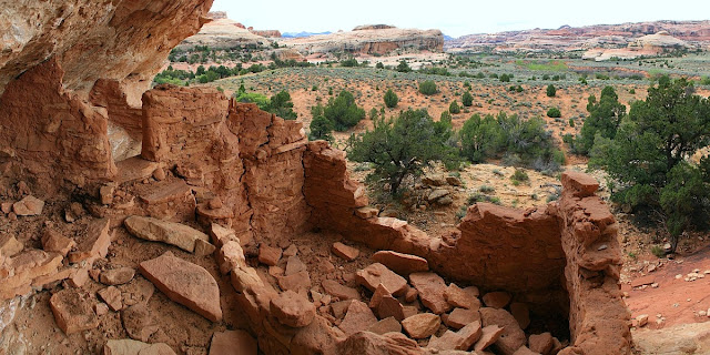
Our first up-close experience with Indian dwellings came farther down the trail. A multi-room ruin was perched about 30 feet up in an alcove, not far off the trail. Here we saw our first of many collections of pottery shards that previous visitors had arranged on rocks near the ruins. This was a magical place for me, where I could walk between the rooms and get a sense of what it would have been like to wake up in this alcove, overlooking this beautiful scenery. We were, of course, scrupulously careful in this location, as in all others, to avoid touching or approaching too closely the ruins themselves. These have withstood over 800 years of weathering, and we wanted to leave them absolutely undisturbed!
Image 6: Alcove Ruin
Image 7: Alcove Condos
Image 8: Rock Textures
Big Ruin was our next stop. We could see the remarkably preserved complex as we approached for at least a 1/2 mile, but it took some doing to find a way down into the arroyo and back out the other side so that we could get a close-up look. I honestly wish the Park Service would just designate an official spur trail to this site, so we could avoid having to blaze our own trail, as many others had obviously done before us. Getting there involved a round-trip mile or more of bushwhacking and scampering over slickrock.
Big Ruin is, according to the information we had, the largest ruin in Canyonlands National Park, consisting of more than 20 dwellings plus granaries. Once we approached it, it became all the more impressive because almost all of it sits on a shelf at the top of a 30-foot vertical cliff, the bottom six feet or so being severely undercut. I tried to imagine raising a toddler up there.
Image 9: Canyon View from Big Ruin
Image 10: Big Ruin
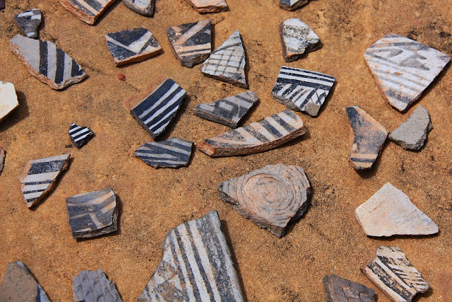
We saw small artifacts at many of the sites we visited, but some of the best were at Big Ruin. Here we were treated to expansive displays of pottery shards, grinding stones, and even a few corn cobs that had somehow survived over 800 years in the open air. Frankly, I was astonished that those finger-sized cobs are still around for us to admire. No wonder corn makes such effective roughage!
Image 11: Grinding Stone (Mano and Metatate) and Corn Cobs
The pottery shards were really quite beautiful; such a variety of painted patterns and sculpted textures were represented.
Image 12: Sundry Pottery Shards
After bushwhacking our way back to the main trail, we took a short spur trail over to Wedding Ring Arch to enjoy the impressive view. This is actually a double arch, with the other opening at a 90-degree angle, behind it on the left. You can see the other arch from farther down the trail if you look back.
Image 13: Wedding Ring Arch
The next ruins site we encountered sort of blew me away. I love the redrock desert, and prior to the trip, had most anticipated admiring nature's handiwork in this canyon. However, after spending 30 minutes exploring these ruins, I found myself rather infatuated with the human marks on this land--even more so than the natural beauty of the place.
It is a little hard to describe, but in this place I felt a sense of sacredness that overtook me unexpectedly. This site had everything I had seen before: rock structures, pictographs, and small tools and pottery shards. However, this place had a few features that were unique among everything else we saw.
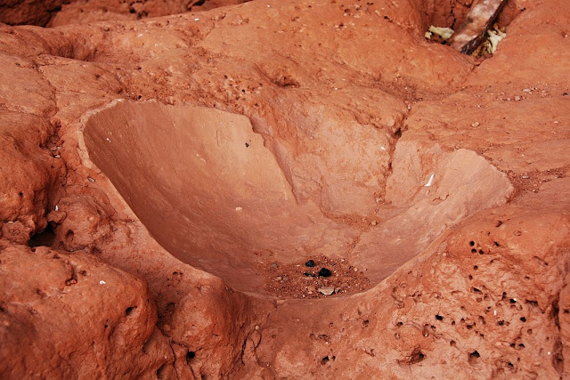
First, it had a bar of clay-like rock that had what appeared to be large cysts--deep holes that probably served as an ancient pantry--placed at semi-regular intervals. There were a couple of almost ceramic-looking bowls created in depressions of this layer. This was new and fascinating.
Images 14, 15, 16: Storage Cysts and Installed Metatates
However, the feature of this site that really blew me away was the garden. Adjacent to the granaries there are more than a dozen squash plants that have apparently been reseeding each year for the last 800 years. It seemed like one badly placed footprint might kill one of these seedlings and forever disrupt this amazing chain of survival. I had heard of this place in prior descriptions of this hike, but I was honestly dumbfounded to find myself standing next to this incredibly fragile, incredibly durable, living relic left behind by our long-distant kin. Something about those green, living, breathing artifacts brought me very close to them and seemed to entwine us as one large, human family across the centuries that separated us. To see something like that in person felt like I was witnessing a miracle. For me, it was nothing short of pure magic.
Image 17: This Year's Crop From Last Year's Seeds
Image 18: Garden Granaries
Image 19: Canyon View Near Garden Granaries
We followed the base of the cliffs around several turns looking for more ruins, and did not find any. However, we did discover another clump of what looked like the same squash plants. Perhaps a second planting area, or seeds spread by animals?
Image 20: Garden Granary Cliffs
Image 21: Giant Mushroom North of the Garden
The next treat was some ruins nestled up in a pair of vertically-oriented alcoves. The first of these was pretty high up a vertical crack. There would have been no way to climb up there without disturbing the walls of the ruins.
Image 22: Crack Ruins
The second of this set of ruins is home of one of the most famous and delightful pictographs found anywhere: the "All-American Man."
Image 23: The All-American Man
Sometimes poetry is the only way to adequately express the feelings stirred by such artistry:
Oh say can you see, on the rust-colored rocks,
He whose loincloth we love, which doth stir such devotion,
Whose lone star and bright stripes, wispy head, and tube socks,
Doth delight all who see his broad smile and emotion?
Oh, never mind. I'll just say that the "All-American Man" is undisputedly, undeniabley AWESOME!
Image 24: The All-American Man and Adjacent Ruins
Image 25: Honeycomb in All-American Man Alcove
After Big Ruin, the Garden, and the All-American Man, I figured we had about maxed out the delights of a single day. It was late in the afternoon when we arrived at our next stop, the "Four Faces."
These pictographs were part of a ruin apparently belonging to the Freemont Indians, who may have intermingled with the Anasazis in this area. For me, these were another treat. Notice how you can see additional figures in faded blue paint between the remaining red figures.
Image 26: Four Faces Ruin
Image 27: The Four Faces
Image 28: View from the Four Faces
We camped that first night in Salt Creek campsite 3, which was in a nice spot with fantastic scenery, not far downstream from the Four Faces. There is even a small ruin on a cliff that can be seen from the camp. Just before reaching camp, we were passed by four rangers who were doing maintenance work of some type. These were the first people we had encountered all day.
As we began our hike the following morning, the first treat of the day was Upper Jump, where the water drops about 15 feet into a large pool. In this area the canyon narrows quite a bit, and stays that way for many miles. This made for a beautiful, shady setting to sit and enjoy the cool morning air and the sound of the water.
Image 29: Upper Jump 1
Image 30: Upper Jump 2
The first and last notable ruins we explored on our second day were an expansive Anasazi ruin that spanned several hundred feet along the cliffs, following a soft layer of sandstone that had eroded into a perpetual alcove. This layer provided both an ideal habitat protected from the elements, as well as most of the building materials needed. This layer stretched for miles down the canyon and it was sometimes hard to distinguish from a distance between man-made ruins and eroding areas in the cliff that looked a lot like stacked bricks.
It was fun to explore the multistory ledges extending around corners of the cliffs and see all the structures that still remained. The view was incredible here too--the canyon makes a strong curve and there were panoramic views from most of the huts. In the 180-degree panoramic photo below, another series of huts is visible in the distance on the left.
Image 31: Panoramic View from a Top-Story Hut.
Image 32: Bottom-Story Huts
Image 33: Near and Far Huts
Image 34: Granary Under the Rock
Image 35: Family Car Rear-Window Sticker
After these ruins we spent the rest of the morning traversing thick, swampy growth in the narrower canyon. Several times we lost the trail and had to whack our way through tamarisk groves. By lunch time we had arrived at the spur trail to Angel Arch. This part of the hike was actually the main draw for coming to Salt Creek in the first place. We had seen photos of Angel Arch for years and wanted to see the spectacle for ourselves. Even though it added another 4 miles or so to our hike, kicking the total up to around 30 miles, it was well worth it! This ended up being the favorite part of the whole trip for some in our group.
Image 36: Side Canyon along the Trail to Angel Arch
This is the view of Angel Arch I had always seen, taken next to a crazily-balanced rock pinnacle that sometimes also shows up in the photos. What I didn't realize is that the arch is huge, and you are still quite a distance from it at this point--probably at least a half mile or so.
Image 37: Classic View of Angel Arch
We discovered that the trail goes on from here, and we all got more and more excited as it began to gain elevation. I told my friend that I might explode with happiness if the trail took us right up to the arch. It did. At one point we wondered if we had reached the end, when the trail suddenly stopped at the bottom of a box canyon with a steep, sandstone slope up the left side. But we saw a cairn up above and scrambled up the slope. Another time the trail went right up a small cliff face where you had to pull yourself up some rocks while your body dangled over an open space about 10 feet off the ground (or, we discovered, you could go around a pillar and squeeze through a crack leading to the same place). As we twisted and turned up the side of a huge box canyon, we finally found ourselves standing inside the arch! Best national park trail ever!
Standing inside the arch, I was astonished at how thin the rock fin is. The enormity of the "angel" feature on the right side of the arch belies how incredibly delicate it looks when viewed on-end.
Image 38: 90-Degree Panoramic View Inside Angel Arch
Image 39: Canyon View From Angel Arch
Tired from our steep ascent and exhilarated to be at such a vantage point where we were looking across the tops of the canyon walls into the far distance, we paused for a long time in the shade of the arch. A few of us actually dozed off while a slight, steady breeze refreshed us.
Image 40: Panoramic Canyon View From Angel Arch
After Angel Arch, we passed two guys camping near the creek, the only people we saw that day. As evening approached, we became a little antsy to find a suitable camp site ourselves in the at-large camping area. The views were gorgeous, however, as the canyon bottom became a solid bed of slickrock for a half mile or so. We noticed several sets of deep gouges in the rock created by jeeps decades ago, when it used to be legal to drive all the way up to Angel Arch.
Image 41: Canyon Reflections
Not too much farther downstream we found a great site and enjoyed the dramatic light cast by the setting sun as it passed down through the layers of clouds that had floated over us all day.
My friend named an arch on the left-side cliffs "The Kissing Bears."
Image 42: Sunset Canyon View
Image 43: 120-degree Panoramic View With Kissing Bears Arch
The third day we had to cover a lot of distance to get back to our truck and get home at a decent hour. We packed out fairly early and enjoyed the benefits of a heavy cloud cover most of the day, which was nice since the canyon had widened out again and there wasn't much shade. Thankfully, we never did encounter any bears, though this was the portion of the canyon where they had been reported so often that season. We did see what appeared to be bear scat several times though.
Image 44: Wildflower Slope
The last interesting landmark, about four miles from the end, was Peek-a-boo Arch with its pictograph panels. Here we met the final two people during our three days in the land of the Freemonts and Anasazi. They were a nice couple from Australia and said the landscape reminded them of home.
Image 45: Peek-a-boo Arch and Pictographs
For three days and thirty miles, our eyes had been perpetually delighted by the amazing landscape we had traversed. Our imaginations had been elevated and our feelings stirred at discovering anew the relics left behind by the amazing people who were stalwart enough to call this place home. How grand it is to leave modern civilization behind and experience the fantastic hues of the cliffs and sky, the hush of wind, the grit of sand, and the cool splash of water in a desert oasis. For a brief time, we were transported into another realm of existence--a place of natural and historical wonder, largely unknown and almost completely unspoiled.
And we got to witness for ourselves that spectacular, all-American loincloth.


No comments:
Post a Comment